
Fil:Lascar Stoa of Attalos - Ancient Agora of Athens (4517779606).jpg

Storlek på förhandsvisningen: 800 × 531 pixlar. Andra upplösningar: 320 × 213 pixlar | 640 × 425 pixlar | 1 024 × 680 pixlar | 1 280 × 850 pixlar | 2 560 × 1 700 pixlar | 3 216 × 2 136 pixlar.
Originalfil (3 216 × 2 136 pixlar, filstorlek: 1,99 Mbyte, MIME-typ: image/jpeg)
.jpg)
Sammanfattning
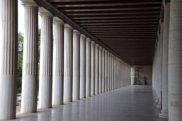
| Beskrivning | The Ancient Agora of Athens is the best-known example of agora, located in Athens, Greece. The Stoa of Attalos (also spelled Attalus) is recognised as one of the most impressive stoa in the Athenian Agora. It was built by and named after King Attalos II of Pergamon who ruled between 159 BC and 138 BC. Typical of the Hellenistic age, the stoa was more elaborate and larger than the earlier buildings of ancient Athens. The stoa's dimensions are 115 by 20 metres wide and it is made of Pentelic marble and limestone. The building skillfully makes use of different architectural orders. The Doric order was used for the exterior colonnade on the ground floor with Ionic for the interior colonnade. This combination had been used in stoas since the Classical period and was by Hellenistic times quite common. On the first floor of the building, the exterior colonnade was Ionic and the interior Pergamene. Each story had two aisles and twenty-one rooms lining the western wall. The rooms of both stories were lighted and vented through doorways and small windows located on the back wall. There were stairways leading up to the second story at each end of the stoa. The building is similar in its basic design to the Stoa that Attalos' brother, and predecessor as king, Eumenes II had erected on the south slope of the Acropolis next to the theatre of Dionysus. The main difference is that Attalos' stoa had a row of rooms at the rear on the ground floor that have been interpretted as shops [Wikipedia.org] |
| Datum | |
| Källa | Stoa of Attalos - Ancient Agora of Athens |
| Skapare | Jorge Láscar from Australia |
| Kameraposition | | Se denna och andra närliggande bilder på: OpenStreetMap |
|---|
.jpg¶ms=037.975000_N_0023.724167_E_globe:Earth_type:camera_source:Flickr_&language=sv)
Licensiering
Denna fil har gjorts tillgänglig under licensen Creative Commons Erkännande 2.0 Generisk
- Du är fri:
- att dela – att kopiera, distribuera och sända verket
- att remixa – att skapa bearbetningar
- På följande villkor:
- erkännande – Du måste ge lämpligt erkännande, ange en länk till licensen och indikera om ändringar har gjorts. Du får göra det på ett lämpligt sätt, men inte på ett sätt som antyder att licensgivaren stödjer dig eller din användning.
| Denna bild laddades ursprungligen upp på Flickr av Jorge Lascar på https://www.flickr.com/photos/8721758@N06/4517779606. 2 april 2014 granskades den av roboten FlickreviewR och befanns vara licensierad under licensen cc-by-2.0. |
Filhistorik
Klicka på ett datum/klockslag för att se filen som den såg ut då.
| Datum/Tid | Miniatyrbild | Dimensioner | Användare | Kommentar | |
|---|---|---|---|---|---|
| nuvarande | 2 april 2014 kl. 11.21 | | 3 216 × 2 136 (1,99 Mbyte) | Russavia | Transferred from Flickr |
Bildlänkar
Följande sida använder den här filen:
.jpg)